 Some time ago I came across the Geobloggers in Flickr. They tagged their photos with the location (in latitude & longitude), which seemed very cool to me. Well how to do it?
Option ONE: is spend a lot of money and get a camera with a GPS built in. (even I considered this a bit extravagant, but I bet it will be a common comsumer level feature before to long) Such cameras store the location within the EXIF data embedded in the header of Jpeg files. A sub option might be to have a seperate GPS and note down your location when you take each photo (hmmm more notes, mess and transciption, no thanks)
Option TWO: Use websites that give you lat & long location. For Australis try Geoscience Australia's Place Name Search or Charles Sturts University's Guide to Australia and then use cut and paste as I am uploading the photos (hmm a bit tedious, but free!)
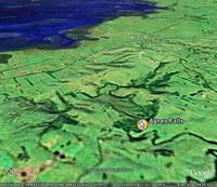
Option THREE: & the most fun! use google earth. Without much effort you can zoom down onto the place you took the photo. You can even leave place markers (as I have done for agnes falls in the image above). The only disappointment is I have to retype in the coordinate for my geotags as I upload my photo to flickr. (hmmm i need to investigate ways to simplify this)
No comments:
Post a Comment